 3 months ago
36
3 months ago
36
Listen to this article

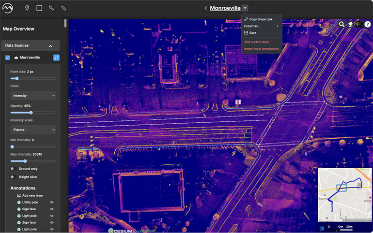
Faster production of mapping data can cut costs for the construction industry, says Mach9. Source: Mach9 Robotics
Autonomous vehicles, delivery robots, and aerial drones all rely on geospatial data, as do construction and utility firms. Mach9 Robotics Inc. said it takes 3D data from lidar scans and turns it into 2D and 3D engineering models faster and cheaper than with conventional methods.
“Just as CAD software allowed GPS to revolutionize the surveying industry, we set out to build powerful tools that could unlock the potential of mobile mapping,” said the company. “We’re building the fastest geospatial production software capable of simplifying and interpreting complex 3D data sets into engineering drawings at incredible speed.”
“We’re building a new category — automated geospatial production and detailed maps,” said Alexander Baikovitz, co-founder and CEO of Mach9.
Baikovitz worked under Chuck and Red Whittaker at Carnegie Mellon University’s (CMU’s) Robotics Institute, as well as with the U.S. Department of Energy and DARPA and other infrastructure owners.
“We built a lot of systems and in hindsight realized that we were solving a lot of hardcore surveying and mapping problems, not just purely robotics problems,” he told The Robot Report. “A lot of the technology that we were building at Carnegie Mellon was immediately addressable for automating a lot of really complex, labor-intensive workflows in an industry where there are substantial labor shortages.”

Mach9 focuses on automated image processing
The global infrastructure market is estimated at $3 trillion, said Mach9 Robotics. The Pittsburgh-based company started with building hardware for mobile mapping systems combining lidar and imaging sensors.
“Inevitably, we ended up moving the company to a software-only offering, which we call Mach9 Digital Surveyor,” recalled Baikovitz. “We built the software to automatically extract features from large-scale lidar and imagery data sets, typically a process that’s done by hand and computer-aided design [CAD] software.”
Mach9 has left the mobile collection of lidar data to companies such as Trimble and Riegl, while drone service providers like Skydio handle the competitive area of drone data and photogrammetry, said Baikovitz.
“There’s a growing abundance of information, and we’re helping our partners turn it into actionable maps and deliverables that they can use for decision making, design, asset management, and other workflows,” he said. “We deliver a lot of information in different ways that are customized by what our customers are looking for. We work very closely with our partners to make sure that our software is delivering the insights and information exactly like how they want and need it.”
Mach9’s product can reduce the processing time from two to four days per mile to 10 minutes, Beikovitz claimed. He said this enables surveyors to be more efficient and take on bigger projects.
“There are many tools that will use SCADA [supervisory control and data acquisition] or sensor data or just static imagery data, but our company is equipped to really enable the use of three-dimensional data,” he said. “This is going to be a fundamental part as to how 3D, BIM [building information management] representations of the world can be used in physical world simulation and modeling for a wide range of infrastructure and civil engineering applications.”
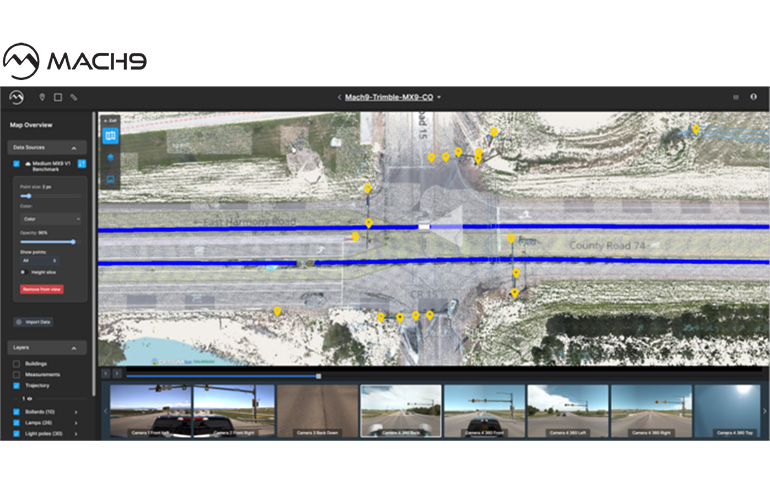
Digital Surveyor helps ArcGIS users use AI-powered mobile mapping for network-scale GIS. Source: Mach9 Robotics
Pittsburgh provides an on ramp for startups
In addition to CMU, the Pittsburgh area provides plenty of resources to help technology startups scale, said Baikovitz.
“There are so many opportunities for companies to be able to grow through a phenomenal network of companies, educational institutions, nonprofit organizations, and the Pittsburgh Robotics Network,” said Baikovitz. “There are great grants, competitions, and incubators that provide space, resources, and support for organizations to get off the ground and for people of all ages and backgrounds to build companies from the ground up.”
“It’s a very collaborative environment, where people of all different ranges of experience help one another figure out how to work through those growing pains of building their first products, understanding their market, selling to their first customers, and eventually building an enduring business,” he added.
U.S. construction industry comes around to adoption
The construction industry has historically been slow to adopt new technologies, but developers who understand the sector can overcome that challenge, said Baikovitz.
“Obviously, there are challenges in bringing technology into industries that have not been served well by software, and the reason why is because there are established workflows in doing things,” he explained. “Construction and infrastructure are part of the largest GDP spends in the entire world, and it’s often the greatest consumer of materials and labor of any particular industry.”
Baikovitz said that demonstrating the ability to solve problems for partners helped Mach9 figure out its wider value proposition.
“One of our early partners was Michael Baker International, a Pittsburgh-based architecture and engineering firm, and the people there have been a phenomenal influence in understanding the industry,” he noted. “Our technology and services can be combined to solve problems for professionals working on everything from transportation infrastructure to utilities and telecommunications, to rail and many other critical industries.”
Mach9 works with leading CAD and geographic information systems (GIS) providers and plans to work with construction management and asset management software providers.
“Whether it’s autonomous driving, personal robotics, broadly geospatial platforms, it’s going to come down to data interoperability,” said Baikovitz. “It’s a challenge that many organizations and many industries are solving. There’s definitely more work to be done making sure that all these different data formats — whether collected from robots or sensor systems, or manually generated by humans — are accessible, addressable, and open.”
“The U.S. has recognized that infrastructure is under-invested,” he said. “We’re excited to be supporting some of the major projects of our generation, with a lot of engineering firms, construction organizations, and others building the future of America’s infrastructure.”


 English (US) ·